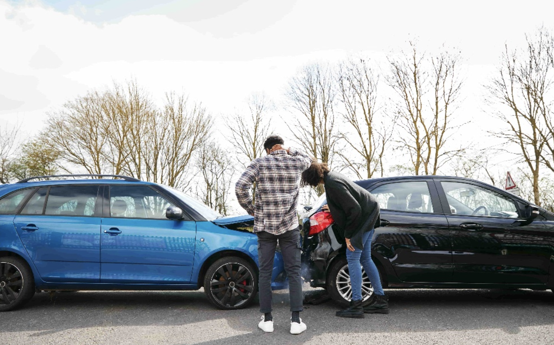
Accident-prone roads in Cambridgeshire…
With the government set to announce their Road Safety Strategy, we take a look at some of Cambridgeshire’s most dangerous roads since 2017.
The government has just announced the first details of the first Road Safety Strategy in over a decade, giving road users a glimpse into what to expect for potential changes in the near future.
First reported by The Times, one of the proposed measures includes compulsory eye tests for drivers over 70 – as well as a reduction in the drink-driving limit, points on licenses for not wearing seatbelts and more.
This is a small peek into a range of new laws that could come into effect following the government’s new Road Safety Strategy, set to be released this autumn.
To take a closer look at why this review is so important, personal injury solicitors, Beecham Peacock (https://www.beechampeacock.co.uk/personal-injury/), have reviewed the latest collision data released by the Department of Transport – which, at the time of writing – is for Cambridgeshire.
Which Roads Have the Most Road Traffic Accidents in Cambridgeshire? (2017–2025)
|
Road |
Total Collisions |
Crashes involving death(s) and/or Serious Injury (KSI)* |
Fatal |
Serious |
Slight |
|
A14 |
531 |
121 |
16 |
105 |
410 |
|
A1134 |
441 |
104 |
1 |
103 |
337 |
|
A1307 |
348 |
97 |
14 |
83 |
251 |
|
A10 |
296 |
99 |
14 |
85 |
197 |
|
A141 |
250 |
70 |
12 |
58 |
180 |
|
B1040 |
215 |
56 |
5 |
51 |
159 |
|
A1303 |
207 |
61 |
6 |
55 |
146 |
|
A142 |
196 |
51 |
12 |
39 |
145 |
|
A1 |
176 |
40 |
3 |
37 |
136 |
|
A603 |
167 |
41 |
2 |
39 |
126 |
|
Unclassified roads |
3439 |
898 |
39 |
859 |
2541 |
Note: KSI data records an instance of death or serious injury; it does not reflect the total deaths or injuries. For example, there could be two deaths in one entry, but it would still be recorded as one instance of KSI.
After we disregard the Cambridgeshire collision data with unclear or unclassified roads, we can see that the A14 (531 collisions), A1134 (441 collisions) and A1307 (348) are the three highest-collision roads – with the A10 and A141 following behind in fourth and fifth.
“Unclassified roads” refer to entries within the data sheet that don’t fall into the A, B or C categories – as well as roads not clearly defined within the data to be analysed.
Why are these roads so accident-prone?
These roads are more dangerous than most for a range of reasons, but in summary, these roads are recognisable to most locals for a few distinct reasons.
A14 – The backbone of Cambridgeshire’s road network, the A14 carries thousands of lorries and long-distance commuters every day. Locals will know it as a constant source of congestion, particularly near Huntingdon and the busy Cambridge junctions.
A1134 (Cambridge Ring Road) – A tight loop around Cambridge, made up of well-known stretches such as Milton Road, Chesterton Road and Trumpington Road. It’s notorious for bottlenecks, buses squeezing through and a dense flow of cyclists.
A1307 (Cambridge–Haverhill Road) – A familiar commuter route for anyone travelling from Haverhill or the south Cambridgeshire villages into the city. Long, fast stretches combine with sudden junctions, turning traffic and a history of fatal crashes, particularly around Linton and Horseheath.
Notable junctions
Here’s a closer look at some of the collision hot spots on the top three worst roads, so you know where to be extra careful should you visit these locations. All screenshots are taken from CrashMap, using data taken from the Department of Transport, and map data supplied by Google Maps.
A14/M11 Interchange
An interchange which often comes up in online discussions, the already long A14 has seen multiple collisions where it meets the M11 – with notable points of frustration including the Girton Interchange and Spittals Interchange, closer to Huntingdon.
While less clustered, collisions are consistent across the A14, ramping up as commuters get closer to Cambridge city centre.
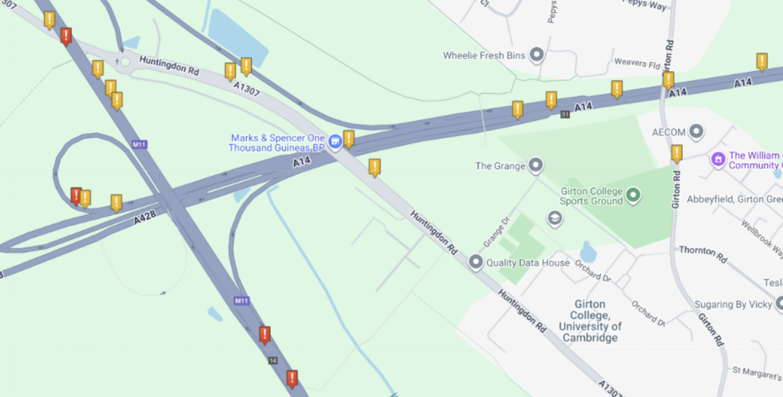
CrashMap |2019–2023 | Google Maps
A1134, Trumpington Rd Roundabouts
A double roundabout leading into Trumpington Road, it’s no surprise that this is a clear hotspot for collisions.
The Trumpington Road roundabouts sit on a busy section of the Cambridge ring road where city traffic, buses, and a constant flow of cyclists all converge.
The double-roundabout layout creates confusion, with drivers often misjudging lane choices or failing to spot cyclists and pedestrians crossing. Add in congestion at peak hours and the sheer mix of road users, and it becomes a prime spot for collisions compared with simpler junctions in the county.
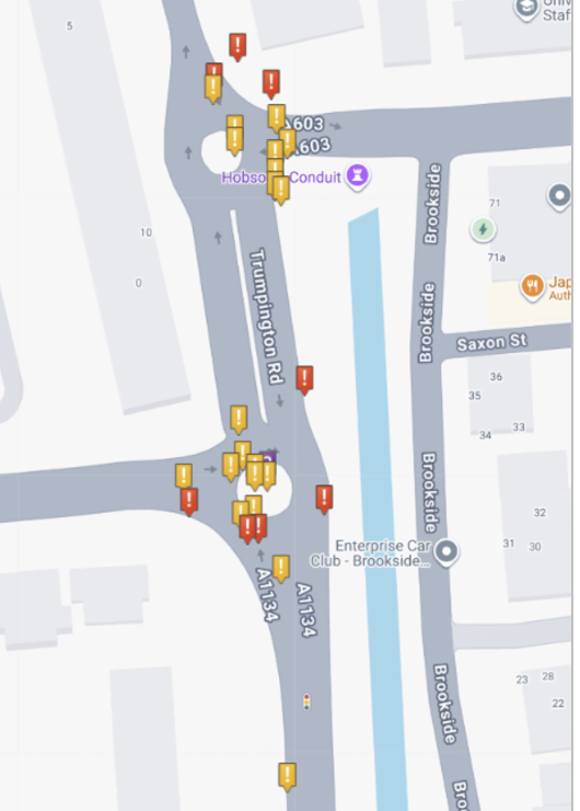
CrashMap |2019–2023 | Google Maps
A1134, Milton Rd Junction
The Milton Road junction on the A1134 is one of Cambridge’s busiest pinch points, funnelling traffic from the Science Park, A14 and northern villages into the city. With heavy commuter flows, frequent buses and large numbers of cyclists using the same space, visibility is often poor and lane discipline breaks down.
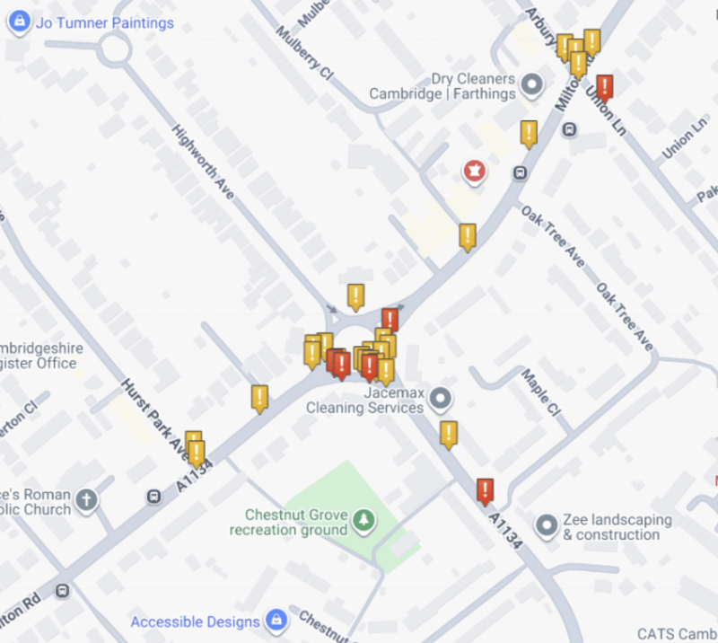
CrashMap |2019–2023 | Google Maps
A1307, Brabham Road
One of the many busy roads into Cambridge, Brabham Road on the A1307, has a series of reported collisions on the outside of the city border – including serious incidents, minor incidents and a couple of fatalities.
Narrow lanes, limited visibility around bends, and frequent traffic – especially near Wandlebury Country Park and the Gig Farm Shop – seem to have increased the collision rate on the build-up to Cambridge.
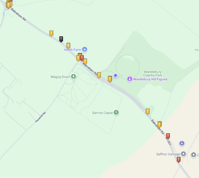
CrashMap |2019–2023 | Google Maps